|
|
|
12.221 Field
Geophysics |
|
Instructors Brad Hager, Tom Herring |
|
IAP 2011 |
Description
|
Course
provides an introduction to practical methods of modern geophysics including
the Global Positioning System (GPS), gravity, and seismology. Fieldwork is conducted in western US
and includes intensive 7-day field exercise. Focus is on measurement
techniques and their interpretation. Subjects discussed include an
introduction to the science of gravity, GPS and field seismology. In field trip we will measure crustal
structure, fault motions, tectonic deformations, and the local gravity field.
Students perform high-precision measurements and participate in data
analysis. Emphasis is placed on the principles of geophysical data collection
and the relevance of these data for tectonic faulting, crustal structure, and
the dynamics of the earthquake cycle |
|
|
|
2004 field
camp web site is 12.221_2004 |
|
2005 field
camp web site is 12.221_2005 |
|
2008 field
camp web sits is 12.221_2008 |
|
|
|
Contacts: |
|
Brad Hager 54-622
253-0126, bhhager@mit.edu |
|
Thomas
Herring, 54-820A, 253-5941, 617-980-9526 (cell) tah@mit.edu |
|
|
Detailed Aims of IAP 2011 Course:
|
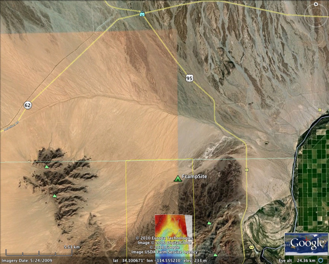
This year's
camp will be held near Vidale California in the
Riverside Mountains. We will be
looking at two basic topics in the course (a) development of a sub-surface
model for the structure in the region using seismology and gravity
measurements collected at field camp with previous gravity measurements and
(b) Measurement of any motion of GPS marks in the region by comparison of our
static GPS measurements with results from previous GPS surveys. Post-camp analyses will focus on
addressing these two problems and combining the data collected this year with
other data. We will be
interested in the possible effects of ground water use on the surface
positions of GPS monuments. |
Dates:
Course starts: Monday January 3, 2011
Field Date:
Thursday, January 6 to Friday January 14, 2011 (We arrive at camp on
Thursday and depart one week
later. We leave Palm Springs on
Friday (after cleaning up)
Class completion: Nominally Friday, January 21. 2011 but may extend a few days into the
last week of IAP>
|
Logical information: |
|
Items to bring to camp: |
|
* Valid picture ID: Either
driver's license or passport.
Note: MIT ID or a copy of a passport is not acceptable form of ID. |
|
*
Tent |
|
*
Sleeping bag (long-range forecast is for 40 deg nights and 60-70 deg during
day). Lows of 30 have been
recorded in this area. |
|
*
Ground sheet/Sleeping pad |
|
*
Sturdy boots (sufficient to handle rough terrain) |
|
*
Sturdy pair of gloves |
|
*
Sturdy water bottle |
|
*
Hat for sun protection |
|
*
Flashlight (extra batteries) |
|
*
Sun block and moisturizer (air will be dry at 300m altitude) |
|
*
Field notebook, pens, calculator, GPS hand held (if you have one) |
|
*
Laptop computer if you have one you want to bring |
|
*
Some snacks, trial mix, gum (All food will be provided while in camp) |
|
*
Books to read during "off-times" |
|
*
Personnel items and clothing for 7 days in field. Layering of clothing is best for day and night conditions.
|
|
*
Swimming gear for stays at hotels |
|
Flight Itinerary |
|
Depart
Logan Airport: US Airways US 506/US2918 |
|
6:10 AM, Thursday Jan 06,
2011, Boston to Phoenix to Palm Springs |
|
Arrive Palm Springs 11:19
am, pick up equipment, drive directly to field camp. Travel time to camp will be about 3.0
hours. |
|
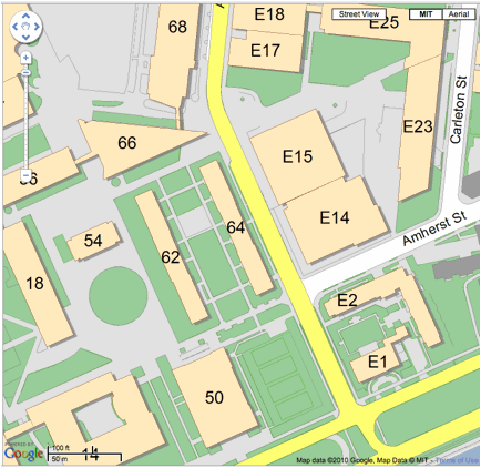
Meet between Biology (68) and Chemical
Engineering (66) on Ames Street at 4:00 am Thursday morning. |
|
Return:
US Airways US 2730/221, |
|
9:07 AM Friday Jan 14,
Palm Springs to Phoenix to Boston |
|
Arrive Boston 8:17 pm. |
|
Thursday Jan 13; 1-night
COURTYARD PALM SPRINGS 1300 TAHQUITZ CANYON WAY PALM SPRINGS CA 92262 760-322-6100 |
Meet Here 4:00 AM Thursday, Jan 6, 2011

Camp location:
Latitude
34.062513491, Longitude 245.455947955, Ellipsoidal Height 234.526 (m).
Results accurate to a few
millimeters!
|
Class Notes |
|
Lec 1 |
|
|
Basic introduction to
class |
|||
|
Lec 2 |
|
|
Introduction to gravity |
|||
|
Lec 3 |
|
|
Introduction to GPS |
|||
|
Lec ? |
Introduction to seismology |
Results from 2008:
Matlab processing folder: Gravity08
Kml files for Google Earth: KMZfiles
Data and Results from 2005-2005 previous years.
The files below contain data
and matlab programs from the 2005+2004 data sets.
Code_Final_bhh.m Matlab code for displaying and reducing data
fc04.dat FC2004
gravity data
fc05.dat FC2005
gravity data
ctides.dat Earth tide
corrections for 2004 data
tides.dat Earth
tide corrections for 2005 data
CA_gravity.txt Regional
gravity values
12.221_FinalReport_2005.pdf PDF of 2005 final
report
Field_Geophysics_Paper.doc Word version of
2005 final report
Data and Results 2008
tides_08.txt Tidal
Corrections 2008
Seismic data: Folder vidal08
Gravity Data: Excel Gravity08.xls