12S56 Seminar 3 September 28 – October 12, 2009
Topic
Discussion of results and techniques used to. How do you
measure position without gravity? Geometric systems that use distance
measurement. How to do this? How do you make maps and what is significance?
Primary Aim
Basic aim of this contrast the different types of coordinate
systems: Gravity field based and geometric ones and look at how distances are
measured.
Discussion
How
would we measure distances over large distances? Especially further than we can
see? Over short distances we can use a tape measure but how to measure further.
Triangulation: Measure base of triangle and the angles to
another point. Keep making the
triangles larger. (Method
developed by Snell in the 1500ís).
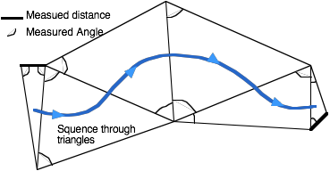
In reality all angles are measured and there is a problem in
the “horizontal” angles at each point are measured relative to local gravity
and so this system is really a mix of geometric and gravity based systems.
By the 1950ís it was possible to measure the distance s directly
using Electromagnetic Distance Measurement (EDM) but still these distances need
to be projected to a level surface.
A global distance measuring system: Can you measure the
distance to a star? Yes: Can you
measure it from different locations sufficiently accurately that you can tell
where the sites are? Usually
astronomical distance measurements are parallax (uses the orbit of the Earth
around the run, brightness of objects (calibrated with parallax to nearby
objects) and velocity of motion (Hubble’s constant and the expanding
universe). None of these
techniques have enough accuracy to tell use where the stations are but we can
change the question and find out where the stations are.
Rather than measure the distances to the star from two
different locations, the difference in distance between to sites is
measured. Technique called very
long baseline interferometry (VLBI) and shown in figure below.
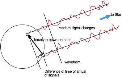
If two sites record signals from a stellar object (in VLBI
normally strong radio emitters called quasars), and the clocks at the two sites
are synchronized then the recorded signals can be cross-correlated in the
difference of the arrival times of the signals measured,
Measurement to a single object determines only one component
of the baseline, perpendicular to the direction to the source. As the Earth rotates, the projected
component of the baseline changes and so this component can be measured
relative to the rotation axis of the Earth. At least one other star is needed to get all the components
of the baseline.
When the stars are at an infinite distance, these
measurements are insensitive to the translation of the system but are very good
for obtaining the relative coordinates of the sites. What would need to changed to get
coordinates relative to center of mass of the Earth?
Map making: Techniques such as triangulation and VLBI (and
even GPS) are too expensive to make maps with. (Too many points would be needed). Most maps are made from aerial photography using ground
points determined by geodetic methods for control of the images. Stereographic photographs are taken so
that height information can also be obtained. With digital photography, digit maps can be directly mad.
Although currently most digit maps (for car navigation systems) are made by
digitizing paper maps.