12S56 Seminar 4 October 7, 2002
Topic
Start looking
at how GPS works. Exercise for
next seminar (Oct 21) will be to measure the circle in front of the Green
building.
Primary Aim
Look at methods of indirect measurement and how they apply to GPS.
Discussion:
In the last seminar we looked at triangulation, which is an indirect method. Today we look at others. Primary indirect method is the measurement of signal time delay. If the velocity of propagation is known and the time delay can be measured, then the velocity times the delay measures the distance. Light travels at 299792458 m/sec (now by definition) and sound travels at about 345 m/s (sound velocity also depends greatly on conditions of atmosphere. It is also relative to the moving air which is fundamentally different to light propagation).
Examples of sound propagation systems are:
(a) Auto focus cameras (in many models but no all)
(b) Sonar depth finding equipment
(c) Seismic earthquake positioning using the difference in travel time between S (Shear waves) and P (pressure or normal sound waves). These waves propagate at different speeds and so with out known exactly when the earthquake occurred you can still calculate the distance to it (and from that when it occurred).
In the VLBI example, we saw how time differences can be measured by cross correlating signals from distant objects. Are there other ways?
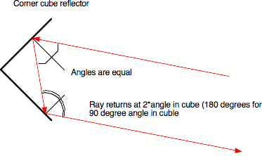
(a) Reflected signal: Send a signal out and have it reflected back and correlate in the outgoing signal with the returned signal. Basically this is how Electromagnetic distance measurement works (show corner cube reflector and how it works).
(b) For GPS this is a problem because it uses radio waves
and so reflector would be very large and it signal retransmitted then number of
uses on the ground would be limited.
(Note both systems, reflectors for optical and retransmission to a small
number of on-ground users are used by other systems. Check LAGEOS and DORIS on the web. For DORIS, DORIS+satellite is better than just DORIS)
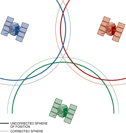
GPS uses a one-way transmission system and is effectively codes its
transmissions with the time (given by the satellites clock) of the
transmission. If the ground clock
was perfect and the satellite clocks were perfect, the time difference could be
converted into a distance from the satellite. The errors in the satellite clocks are monitored by the US
Air force Control Segment and are transmitted as part of the satellites data
message. The ground receiver could
have large errors in its clock, by making measurements to 4 satellites rather
than the minimum of three to determine a 3-D coordinate, the error in the
receiver clock can be estimated.
As an added bonus: GPS not only tells you your position, it also tells you
the time (good to about 10 nanoseconds, 10-9 seconds)
This concept is illustrated below. (From: Herring, T. A., The Global
Positioning System, Scientific America, Feb.,
44-50, 1996.)
EXERCISE 2: Due Monday Nov 7
|
Determine the radius of the circle outside the Green
building. There is a grass inner
ring and a concrete outer ring. The radius of the outer edge of the concrete
ring should be determined. In
the center of the circle is a sprinkler head, use an indirect method (i.e.,
no by direct distance measurement) to determine the distance from the
sprinkler to the outer concrete edge. |