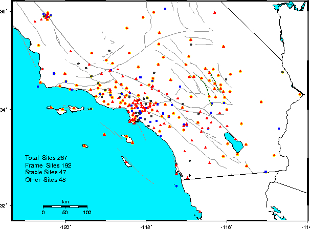
Combined and Center GPS Results


Last Updated Mon Dec 1 01:00:22 EST 2003

Analysis History


Velocity field results.
In the descriptions below, the following terms apply
Stable sites These are sites with random walk process noise less than 2 mm2/yr
Frame sites These are sites with random walk process noise less than 0.5 mm2/yr and are used to realize the daily SCIGN reference frame in times series analysis
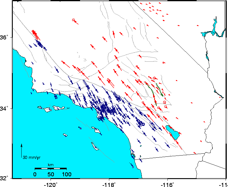
Full Analysis These results are from a foward Kalman filter run with velocities, offsets and post-seismic log coefficients estimated
Time Series Analysis These results are from simple fitting to the time series results. A correlated noise model using successive averging times is used to obtain the uncertainties
Sigmas Attempts have been made to make all sigmas in the combined products realistic using a form of correlated nioise model developed for tsview For the full analysis results, these sigmas reflect in some sense an absolute uncertainity and may be conservative for differential motions bewteen sites. Alternative models are discussed in the SIO Refined Model The sigmas for velocity estimates on the time series plots are not realistic because these are generated from a simple plotting program.


Distribution of sites

Postscript version of figure
Sites in the California part of the SCIGN Network. Red triangles are sites used in the definition of the SCIGN local reference frame. Blue squares are other sites included in full analysis, and black circle are sites that show no-secular motion and are included only in the time series analysis. There are additional sites in Mexico and on Isla Guadalupe (GUAX). The grey lines are quaternary faults; the dark green lines are the Landers and Hector Mine surface ruptures.


Postscript version of figure
Map of the SCIGN velocities from the final combined solution. Vectors in red are closer to the North America plate and are shown relative to North America. Vectors in blue are closer to the Pacific plate and are shown relative to the Pacific Plate. Only sites with velocity sigmas less than 1 mm/yr are shown. Error ellipses show 95% confidence intervals.

In all the velocity files, sites typically appear multiple times with the same velocity estimates. These different site names denote breaks in the time series. The last two characters denote an earthquake: HT is Hector Mine, CO Coso July 17, 2001 earthquake. The third last character denotes other reasons for a break in the time series. In general, names with _Cxx in the name, denote changes from Ashtech Cast to milled choke ring antenna; _Rxx denote changes or additions of radomes; _Txx denotes a Trimble to Ashtech change Other jumps ot unknown origin are denoted with numerical values _1xx, _2xx. The full list of earthquakes and jumps is given in scign.eq GLOBK earthquake file.

Analysis
Description
com_96_0309_fin.vel Combined JPL and SIO results for all stable sites from full analysis. Sites with a * on the name are used to define the SCIGN reference frame. This file also constains the North America and Pacific sites used to define the North American frame for SCIGN
com_96_0309_TS.vel Combined JPL and SIO results for all stable sites from time series analysis
jpl_96_0309_fin.vel JPL only results for all stable sites from full analysis. The JPL stacov files only contain sites in SCIGN region and a * on the sites here denote the local sites used to the reference frame
jpl_96_0309_TS.vel JPL only results for all stable sites from time series analysis
sio_96_0309_fin.vel SIO only results for all stable sites from full analysis
sio_96_0309_TS.vel SIO only results for all stable sites from time series analysis
JPL_2003_09_noam.vel JPL results from JPL table2.txt in North America frame
SIO_2003_09_noam.vel SIO results from SIO refinedModelVelocities.cgi in North America frame
CMM_2003_09_noam.vel SCEC Crustal Motion 3.0 model from vels.final in North America frame. Note: There are no height velocities in this file.


Hector Postseismic Logarithm coefficients.

Postscript version of figure
Vector plot of the north and east coefficients of logarithmic functions fit after the Hector Mine earthquake. The grey lines are quaternary faults, the thick green line is a simplified Hector Mine Ruputure and the brown line is a simplified Landers rupture. The error ellipses show 95% condifidence intervals.

Postseismic results based on data collected shortly after the Hector Mine earthquake and methods used in the SCIGN array are discussed by Hudnut et al., 2002
Hudnut, K. W., N. E. King, J. E. Galetzka, K. F. Stark, J. A. Behr, A. Aspiotes, S. van Wyk, R. Moffitt, S. Dockter, and F. Wyatt, Continuous GPS observations of postseismic deformation following the 16 October 1999 Hector Mine earthquake (Mw7.1), Bull. Seismol. Soc. Amer., vol. 92, No. 4, 1403-1422, 2002.

Example of time series for site OPCL: Observation Point, Creole, Twenty Nine Palms

Figure is from the time series plots. The red symbols are the combined analysis time series, the blue in this case are from the SIO analysis. This site was installed 38 days the Hector Mine earthquake

Analysis
Description
com_96_0309_fin.ln Combined JPL and SIO results from full analysis
com_96_0309_TS.ln Combined JPL and SIO results from time series analysis
jpl_96_0309_fin.ln JPL only results from full analysis
jpl_96_0309_TS.ln JPL only results from time series analysis
sio_96_0309_fin.ln SIO only results from full analysis
sio_96_0309_TS.ln SIO only results from time series analysis


Time series Plots and values

The time series shown here are generated from the daily loose position files from JPL and SIO. For the combined time series, the SIO and JPL loosely constrained files are combined daily and a translation and rotation estimated to align the combined file with the combined motion model. The same approach is used for each center's loosely constrained files to generate time series for each center. The time series generated by the centers are available on the fil_jpl and fil_sio directories on this web site.

These pages are divided into three sets of web pages
Frame definition sites These are the 211 sites used to realize the SCIGN reference frame and are considered to most stable
Stable sites These are the 59 sites that are sufficiently stable that they are included in the full analysis
Other sites These are the 42 sites that have large non-secular motions or corrupt data. The latter sites have _X in there names
Deleted data These are the segments of data that have been deleted from the analysis. Often the deletion is due to antenna or receiver failures
Combined Time Series Combined time series concatinated to single plot per site